
Caney City topographic map
Interactive map
Click on the map to display elevation.
About this map
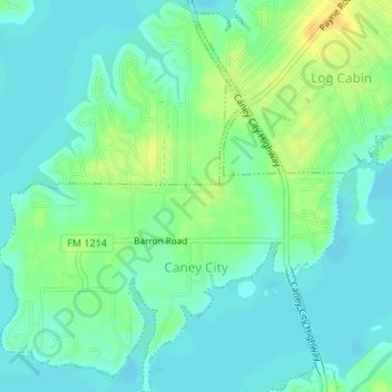
Name: Caney City topographic map, elevation, terrain.
Location: Caney City, Henderson County, Texas, United States (32.19963 -96.05106 32.22791 -96.02137)
Average elevation: 341 ft
Minimum elevation: 312 ft
Maximum elevation: 400 ft
Other topographic maps
Click on a map to view its topography, its elevation and its terrain.
Eustace
United States > Texas > Henderson County
Eustace, Henderson County, Texas, United States
Average elevation: 410 ft
Murchison
United States > Texas > Henderson County
Murchison, Henderson County, Texas, United States
Average elevation: 479 ft
Enchanted Oaks
United States > Texas > Henderson County > Enchanted Oaks
Enchanted Oaks, Henderson County, Texas, United States
Average elevation: 338 ft
Lake Palestine
United States > Texas > Henderson County > Chandler
Lake Palestine, Chandler, Henderson County, Texas, United States
Average elevation: 367 ft
Athens
United States > Texas > Henderson County
Athens, Henderson County, Texas, United States
Average elevation: 459 ft
Log Cabin
United States > Texas > Henderson County > Log Cabin
Log Cabin, Henderson County, Texas, United States
Average elevation: 354 ft