Geolocate

Murchison topographic map

Click on the map to display elevation.

About this map

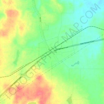
Name: Murchison topographic map, elevation, terrain.

Location: Murchison, Henderson County, Texas, United States (32.25328 -95.78138 32.30348 -95.73683)

Average elevation: 479 ft

Minimum elevation: 377 ft

Maximum elevation: 600 ft

Henderson County trails, hiking, mountain biking, running and outdoor activities

Other topographic maps

Click on a map to view its topography, its elevation and its terrain.

Moore Station

United States > Texas > Henderson County

Average elevation: 433 ft

Tool

United States > Texas > Henderson County

Average elevation: 325 ft

Gun Barrel City

United States > Texas > Henderson County

Average elevation: 358 ft

Poynor

United States > Texas > Henderson County

Average elevation: 456 ft

Murchison

United States > Texas > Henderson County

Average elevation: 479 ft

LaRue

United States > Texas > Henderson County

Average elevation: 489 ft

Gear up for your next adventure:

🧯Emergency Survival Kit - All‑in‑one survival essentials for the backcountry
📱Solar Portable Charger - Solar power bank for charging devices off‑grid
📻Weather Alert Radios - Stay informed of storm risks while off-the-grid
📶Vehicle Signal Boosters - Improve reception in rural areas while driving to trailheads
📚USA Hiking Guide Books - Top trail guides and map books

As an Amazon Associate, this site earns from qualifying purchases at no extra cost to you.