
Welkom topographic map
Click on the map to display elevation.
Welkom
Koppie Alleen is the only hill near Welkom and therefore is aptly named for its oddity. The terrain elevation above sea level is 1435 metres. The largest water catchment is the Sand River to the south-east of Welkom in Virginia's direction. Large saline pans such as Flamingo Pan and Theronia Pan are situated to the south-west of Welkom. Flamingo Pan is coded as an Important Bird Area (IBA)
About this map
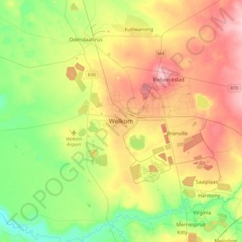
Name: Welkom topographic map, elevation, terrain.
Average elevation: 4,400 ft
Minimum elevation: 4,170 ft
Maximum elevation: 4,711 ft
Other topographic maps
Click on a map to view its topography, its elevation and its terrain.
Masilonyana Local Municipality
South Africa > Free State > Lejweleputswa District Municipality
Average elevation: 4,541 ft
Bloemhof Dam
South Africa > Free State > Lejweleputswa District Municipality > Tswelopele Local Municipality
Average elevation: 4,104 ft
Masilonyana Ward 3
South Africa > Free State > Lejweleputswa District Municipality > Masilonyana Local Municipality
Average elevation: 4,656 ft
Tokologo Ward 3
South Africa > Free State > Lejweleputswa District Municipality > Tokologo Local Municipality
Average elevation: 3,983 ft
Bloemhof Dam
South Africa > Free State > Lejweleputswa District Municipality > Tswelopele Local Municipality
Average elevation: 4,029 ft
Tswelopele Ward 5
South Africa > Free State > Lejweleputswa District Municipality > Tswelopele Local Municipality
Average elevation: 4,249 ft
Sand River
South Africa > Free State > Lejweleputswa District Municipality
Average elevation: 4,491 ft
Matjhabeng Local Municipality
South Africa > Free State > Lejweleputswa District Municipality
Average elevation: 4,514 ft
HJ Joel Nature Reserve
South Africa > Free State > Lejweleputswa District Municipality > Masilonyana Local Municipality
Average elevation: 4,547 ft
Erfenis Dam
South Africa > Free State > Lejweleputswa District Municipality > Masilonyana Local Municipality
Average elevation: 4,449 ft
Tswelopele Local Municipality
South Africa > Free State > Lejweleputswa District Municipality
Average elevation: 4,245 ft
Masilonyana Ward 2
South Africa > Free State > Lejweleputswa District Municipality > Masilonyana Local Municipality
Average elevation: 4,370 ft
Tokologo Ward 2
South Africa > Free State > Lejweleputswa District Municipality > Tokologo Local Municipality
Average elevation: 4,117 ft
Tokologo Ward 4
South Africa > Free State > Lejweleputswa District Municipality > Tokologo Local Municipality
Average elevation: 4,131 ft