
Make a donation
Gear up for your next adventure:
As an Amazon Associate, this site earns from qualifying purchases at no extra cost to you.
Matjhabeng Local Municipality topographic map
Click on the map to display elevation.
Make a donation
Gear up for your next adventure:
As an Amazon Associate, this site earns from qualifying purchases at no extra cost to you.
About this map
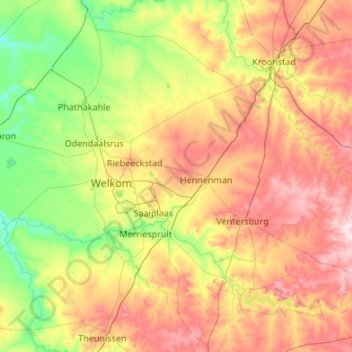
Name: Matjhabeng Local Municipality topographic map, elevation, terrain.
Average elevation: 4,514 ft
Minimum elevation: 4,124 ft
Maximum elevation: 5,180 ft
Make a donation
Gear up for your next adventure:
As an Amazon Associate, this site earns from qualifying purchases at no extra cost to you.
Other topographic maps
Click on a map to view its topography, its elevation and its terrain.
Hertzogville
South Africa > Free State > Lejweleputswa District Municipality > Tokologo Local Municipality
Average elevation: 4,216 ft
Bothaville
South Africa > Free State > Lejweleputswa District Municipality > Nala Local Municipality
Average elevation: 4,222 ft
Welkom
South Africa > Free State > Lejweleputswa District Municipality
Koppie Alleen is the only hill near Welkom and therefore is aptly named for its oddity. The terrain elevation above sea level is 1435 metres. The largest water catchment is the Sand River to the south-east of Welkom in Virginia's direction. Large saline pans such as Flamingo Pan and Theronia Pan are situated…
Average elevation: 4,400 ft
Virginia
South Africa > Free State > Lejweleputswa District Municipality > Matjhabeng Local Municipality
Average elevation: 4,350 ft
Make a donation
Gear up for your next adventure:
As an Amazon Associate, this site earns from qualifying purchases at no extra cost to you.
Hoopstad
South Africa > Free State > Lejweleputswa District Municipality > Tswelopele Local Municipality
Average elevation: 4,104 ft
Bultfontein
South Africa > Free State > Lejweleputswa District Municipality > Tswelopele Local Municipality
Average elevation: 4,350 ft
Winnie Mandela (Brandfort)
South Africa > Free State > Lejweleputswa District Municipality > Masilonyana Local Municipality
Average elevation: 4,603 ft
Theunissen
South Africa > Free State > Lejweleputswa District Municipality > Masilonyana Local Municipality
Average elevation: 4,577 ft
Make a donation
Gear up for your next adventure:
As an Amazon Associate, this site earns from qualifying purchases at no extra cost to you.
Odendaalsrus
South Africa > Free State > Lejweleputswa District Municipality > Matjhabeng Local Municipality
Average elevation: 4,383 ft
Wesselsbron
South Africa > Free State > Lejweleputswa District Municipality > Nala Local Municipality
Average elevation: 4,255 ft
Verkeerdevlei
South Africa > Free State > Lejweleputswa District Municipality > Masilonyana Local Municipality
Average elevation: 4,836 ft
Bloemhof Dam
South Africa > Free State > Lejweleputswa District Municipality > Tswelopele Local Municipality
Average elevation: 4,029 ft
Make a donation
Gear up for your next adventure:
As an Amazon Associate, this site earns from qualifying purchases at no extra cost to you.
HJ Joel Nature Reserve
South Africa > Free State > Lejweleputswa District Municipality > Masilonyana Local Municipality
Average elevation: 4,547 ft
Erfenis Dam
South Africa > Free State > Lejweleputswa District Municipality > Masilonyana Local Municipality
Average elevation: 4,449 ft
Bronville
South Africa > Free State > Lejweleputswa District Municipality > Matjhabeng Local Municipality
Average elevation: 4,478 ft
Bothaville
South Africa > Free State > Lejweleputswa District Municipality > Nala Local Municipality
Average elevation: 4,222 ft
Make a donation
Gear up for your next adventure:
As an Amazon Associate, this site earns from qualifying purchases at no extra cost to you.
Welkom
South Africa > Free State > Lejweleputswa District Municipality
Koppie Alleen is the only hill near Welkom and therefore is aptly named for its oddity. The terrain elevation above sea level is 1435 metres. The largest water catchment is the Sand River to the south-east of Welkom in Virginia's direction. Large saline pans such as Flamingo Pan and Theronia Pan are situated…
Average elevation: 4,400 ft
Bothaville
South Africa > Free State > Lejweleputswa District Municipality > Nala Local Municipality
Average elevation: 4,222 ft
Welkom
South Africa > Free State > Lejweleputswa District Municipality
Koppie Alleen is the only hill near Welkom and therefore is aptly named for its oddity. The terrain elevation above sea level is 1435 metres. The largest water catchment is the Sand River to the south-east of Welkom in Virginia's direction. Large saline pans such as Flamingo Pan and Theronia Pan are situated…
Average elevation: 4,400 ft
Make a donation
Gear up for your next adventure:
As an Amazon Associate, this site earns from qualifying purchases at no extra cost to you.
Highveld
South Africa > Free State > Lejweleputswa District Municipality > Matjhabeng Local Municipality
The Highveld (Afrikaans: Hoëveld, pronounced [ˈɦuəfælt], lit. 'High Field') is the portion of the South African inland plateau which has an altitude above roughly 1,500 m (4,900 ft), but below 2,100 m (6,900 ft), thus excluding the Lesotho mountain regions to the south-east of the Highveld. It is home…
Average elevation: 4,528 ft
Allanridge
South Africa > Free State > Lejweleputswa District Municipality > Matjhabeng Local Municipality
Average elevation: 4,301 ft
Highveld
South Africa > Free State > Lejweleputswa District Municipality > Matjhabeng Local Municipality
Average elevation: 4,528 ft
Odendaalsrus
South Africa > Free State > Lejweleputswa District Municipality > Matjhabeng Local Municipality
Average elevation: 4,383 ft
Make a donation
Gear up for your next adventure:
As an Amazon Associate, this site earns from qualifying purchases at no extra cost to you.
Bothaville
South Africa > Free State > Lejweleputswa District Municipality > Nala Local Municipality
Average elevation: 4,222 ft
Boshof
South Africa > Free State > Lejweleputswa District Municipality > Tokologo Local Municipality
Average elevation: 4,108 ft
Riebeeckstad
South Africa > Free State > Lejweleputswa District Municipality > Matjhabeng Local Municipality
Average elevation: 4,541 ft
Brandfort
South Africa > Free State > Lejweleputswa District Municipality > Masilonyana Local Municipality
Average elevation: 4,603 ft
Make a donation
Gear up for your next adventure:
As an Amazon Associate, this site earns from qualifying purchases at no extra cost to you.
Bultfontein
South Africa > Free State > Lejweleputswa District Municipality > Tswelopele Local Municipality
Average elevation: 4,350 ft
Ventersburg
South Africa > Free State > Lejweleputswa District Municipality > Matjhabeng Local Municipality
Average elevation: 4,718 ft
Winnie Mandela (Brandfort)
South Africa > Free State > Lejweleputswa District Municipality > Masilonyana Local Municipality
Average elevation: 4,603 ft
Virginia
South Africa > Free State > Lejweleputswa District Municipality > Matjhabeng Local Municipality > Virginia
Average elevation: 4,350 ft
Make a donation
Gear up for your next adventure:
As an Amazon Associate, this site earns from qualifying purchases at no extra cost to you.
Winburg
South Africa > Free State > Lejweleputswa District Municipality > Masilonyana Local Municipality
Average elevation: 4,754 ft