
Make a donation
Gear up for your next adventure:
As an Amazon Associate, this site earns from qualifying purchases at no extra cost to you.
Wolfsgrün topographic map
Click on the map to display elevation.
Make a donation
Gear up for your next adventure:
As an Amazon Associate, this site earns from qualifying purchases at no extra cost to you.
About this map
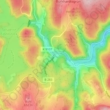
Name: Wolfsgrün topographic map, elevation, terrain.
Average elevation: 1,864 ft
Minimum elevation: 1,473 ft
Maximum elevation: 2,241 ft
Make a donation
Gear up for your next adventure:
As an Amazon Associate, this site earns from qualifying purchases at no extra cost to you.
Other topographic maps
Click on a map to view its topography, its elevation and its terrain.
Eibenstock
Deutschland > Sachsen > Erzgebirgskreis > Eibenstock
Aufgrund der Höhenlage von mehr als 600 m wird Eibenstock nicht zu den allerersten Bauerndörfern im Erzgebirge gehört haben. Es gibt die Einschätzung, es sei als dauerhafte Ansiedlung in Form eines Radialwaldhufendorfes frühestens im Laufe des 13. Jahrhunderts im Bereich der späteren Herrschaft…
Average elevation: 2,464 ft
Sosa
Deutschland > Sachsen > Erzgebirgskreis > Eibenstock
Sosa liegt im Westerzgebirge. Nach der Naturraumkarte von Sachsen gehört es zur Mesogeochore „Bockauer Hochfläche“ und innerhalb dieser zur Mikrogeochore „Sosaer Zerschneidungs-Hang“. Der Ort erstreckt sich zu beiden Seiten des Sosabaches in einer Höhe zwischen 550 und 817 m ü. NHN. Zu Sosa…
Average elevation: 2,306 ft