
Thank you for supporting this site ❤️
Make a donation
Make a donation
Gear up for your next adventure:
As an Amazon Associate, this site earns from qualifying purchases at no extra cost to you.
1065 topographic map
Click on the map to display elevation.
Thank you for supporting this site ❤️
Make a donation
Make a donation
Gear up for your next adventure:
As an Amazon Associate, this site earns from qualifying purchases at no extra cost to you.
About this map
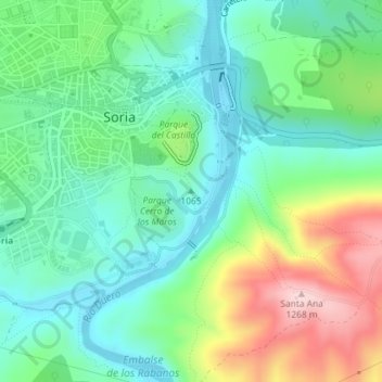
Name: 1065 topographic map, elevation, terrain.
Location: 1065, Soria, Castilië en León, 42002, Spanje (41.75809 -2.45748 41.75819 -2.45738)
Average elevation: 3,556 ft
Minimum elevation: 3,281 ft
Maximum elevation: 4,150 ft
Thank you for supporting this site ❤️
Make a donation
Make a donation
Gear up for your next adventure:
As an Amazon Associate, this site earns from qualifying purchases at no extra cost to you.