
Make a donation
Gear up for your next adventure:
As an Amazon Associate, this site earns from qualifying purchases at no extra cost to you.
Vila do Conde topographic map
Click on the map to display elevation.
Make a donation
Gear up for your next adventure:
As an Amazon Associate, this site earns from qualifying purchases at no extra cost to you.
Vila do Conde
The area of Vila do Conde is part of the granite-metamorphic basement, the Iberian Hercynian massif, that extends from the Spanish border to Espinho (15 km (9 mi) south of Porto). Over the Hercynian bedrock there is a prevalence of sandy beaches, and in other areas, the erosion of these sands has allowed the exposure of the rocky substrata. Most of the rock outcrops (never more than 20 metres) disappear north of the Ave River. Yet, these deposits are irregular, and most comparable sediments are not necessarily found at the same altitude. There are also deformations associated with the last inter-glacial period, that have affected these sedimentary layers, most commonly in the beach of Sampaio, where deposits have been discovered between various altitudes (5 and 9 metres).
Make a donation
Gear up for your next adventure:
As an Amazon Associate, this site earns from qualifying purchases at no extra cost to you.
About this map
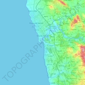
Name: Vila do Conde topographic map, elevation, terrain.
Location: Vila do Conde, Porto, Portugal (41.25549 -8.76805 41.42571 -8.61062)
Average elevation: 95 ft
Minimum elevation: -10 ft
Maximum elevation: 774 ft
Make a donation
Gear up for your next adventure:
As an Amazon Associate, this site earns from qualifying purchases at no extra cost to you.
Other topographic maps
Click on a map to view its topography, its elevation and its terrain.
Make a donation
Gear up for your next adventure:
As an Amazon Associate, this site earns from qualifying purchases at no extra cost to you.
Make a donation
Gear up for your next adventure:
As an Amazon Associate, this site earns from qualifying purchases at no extra cost to you.
Santa Marinha do Zêzere
Portugal > Porto > Santa Marinha do Zêzere > Santa Marinha do Zêzere
Average elevation: 1,394 ft
Make a donation
Gear up for your next adventure:
As an Amazon Associate, this site earns from qualifying purchases at no extra cost to you.
Make a donation
Gear up for your next adventure:
As an Amazon Associate, this site earns from qualifying purchases at no extra cost to you.
Make a donation
Gear up for your next adventure:
As an Amazon Associate, this site earns from qualifying purchases at no extra cost to you.
São Tomé de Covelas
Portugal > Porto > Santa Cruz do Douro e São Tomé de Covelas
Average elevation: 1,168 ft