
Make a donation
Gear up for your next adventure:
As an Amazon Associate, this site earns from qualifying purchases at no extra cost to you.
Sleeping Giant State Park topographic map
Click on the map to display elevation.
Make a donation
Gear up for your next adventure:
As an Amazon Associate, this site earns from qualifying purchases at no extra cost to you.
Sleeping Giant State Park
Sleeping Giant (also known as the Blue Hills and Mount Carmel), (Hobbomock in Quinnipiac), is a rugged traprock mountain with a high point of 739 feet (225 m), located eight miles (13 km) north of New Haven, Connecticut. A prominent landscape feature visible for miles, the Sleeping Giant receives its name from its anthropomorphic resemblance to a slumbering human figure as seen from either the north or south. The Giant is known for its expansive clifftop vistas, rugged topography, and microclimate ecosystems. Most of the Giant is located within Sleeping Giant State Park. The mountain is a popular recreation site: over 30 miles (48 km) of hiking trails traverse it including 5 miles (8 km) of the 23-mile (37 km) Quinnipiac Trail. Quinnipiac University is located at Mount Carmel's foot in Hamden.
Make a donation
Gear up for your next adventure:
As an Amazon Associate, this site earns from qualifying purchases at no extra cost to you.
About this map
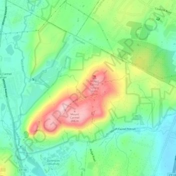
Name: Sleeping Giant State Park topographic map, elevation, terrain.
Average elevation: 259 ft
Minimum elevation: 16 ft
Maximum elevation: 705 ft
Make a donation
Gear up for your next adventure:
As an Amazon Associate, this site earns from qualifying purchases at no extra cost to you.
Other topographic maps
Click on a map to view its topography, its elevation and its terrain.
Mount Carmel Center
United States > Connecticut > South Central Connecticut Planning Region > Hamden
Average elevation: 259 ft
Lake Whitney
United States > Connecticut > South Central Connecticut Planning Region > Hamden
Average elevation: 82 ft
Lake Whitney
United States > Connecticut > South Central Connecticut Planning Region > Hamden > Whitneyville
Average elevation: 82 ft