
Thank you for supporting this site ❤️
Make a donation
Make a donation
Gear up for your next adventure:
As an Amazon Associate, this site earns from qualifying purchases at no extra cost to you.
Cerdas topographic map
Click on the map to display elevation.
Thank you for supporting this site ❤️
Make a donation
Make a donation
Gear up for your next adventure:
As an Amazon Associate, this site earns from qualifying purchases at no extra cost to you.
About this map
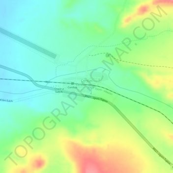
Name: Cerdas topographic map, elevation, terrain.
Location: Cerdas, Uyuni, Antonio Quijarro, Potosí, Bolivia (-20.82014 -66.38951 -20.81548 -66.38183)
Average elevation: 12,713 ft
Minimum elevation: 12,598 ft
Maximum elevation: 12,887 ft
Thank you for supporting this site ❤️
Make a donation
Make a donation
Gear up for your next adventure:
As an Amazon Associate, this site earns from qualifying purchases at no extra cost to you.
Other topographic maps
Click on a map to view its topography, its elevation and its terrain.