
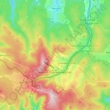
Oberwiesenthal topographic map
Interactive map
Click on the map to display elevation.
About this map
Name: Oberwiesenthal topographic map, elevation, terrain.
Location: Oberwiesenthal, Erzgebirgskreis, Saxony, 09484, Germany (50.40402 12.85948 50.46706 13.02269)
Average elevation: 3,045 ft
Minimum elevation: 2,221 ft
Maximum elevation: 4,098 ft
Oberwiesenthal lies in the county of Erzgebirgskreis, on the border with the Czech Republic that follows the course of the Pöhlbach stream as far as Bärenstein (10 km northeast). The highest elevation in the borough is the Fichtelberg (sometimes called the Großer Fichtelberg or Great Fichtelberg) which, at 1,215 m above NN, is the highest mountain in Saxony.
Other topographic maps
Click on a map to view its topography, its elevation and its terrain.
08289
Germany > Saxony > Erzgebirgskreis > Schneeberg
08289, Griesbach, Schneeberg, Erzgebirgskreis, Saxony, Germany
Average elevation: 1,657 ft
Ehrenfriedersdorf
Germany > Saxony > Erzgebirgskreis
Ehrenfriedersdorf, Erzgebirgskreis, Saxony, 09427, Germany
Average elevation: 1,909 ft
Tannenberg
Germany > Saxony > Erzgebirgskreis
Tannenberg, Verwaltungsgemeinschaft Geyer, Erzgebirgskreis, Saxony, Germany
Average elevation: 1,936 ft
Aue
Germany > Saxony > Erzgebirgskreis
Aue, Aue-Bad Schlema, Erzgebirgskreis, Saxony, 08280, Germany
Average elevation: 1,526 ft
Olbernhau
Germany > Saxony > Erzgebirgskreis
Olbernhau, Erzgebirgskreis, Saxony, 09526, Germany
Average elevation: 2,008 ft
Niederdorf
Germany > Saxony > Erzgebirgskreis
Niederdorf, Stollberg/Erzgeb., Erzgebirgskreis, Saxony, Germany
Average elevation: 1,355 ft
Kühnhaide
Germany > Saxony > Erzgebirgskreis > Marienberg > Kühnhaide
Kühnhaide, Marienberg, Erzgebirgskreis, Saxony, 09496, Germany
Average elevation: 2,493 ft
Andreasberg
Germany > Saxony > Erzgebirgskreis > Auerbach
Andreasberg, Auerbach, Burkhardtsdorf, Erzgebirgskreis, Saxony, 09390, Germany
Average elevation: 1,791 ft