
Thank you for supporting this site ❤️
Make a donation
Make a donation
Gear up for your next adventure:
As an Amazon Associate, this site earns from qualifying purchases at no extra cost to you.
Kühnhaide topographic map
Click on the map to display elevation.
Thank you for supporting this site ❤️
Make a donation
Make a donation
Gear up for your next adventure:
As an Amazon Associate, this site earns from qualifying purchases at no extra cost to you.
About this map
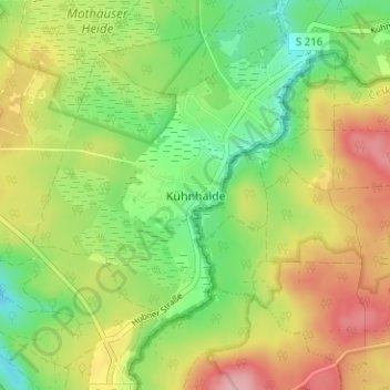
Name: Kühnhaide topographic map, elevation, terrain.
Location: Kühnhaide, Marienberg, Erzgebirgskreis, Saxony, 09496, Germany (50.56070 13.21343 50.60070 13.25343)
Average elevation: 2,493 ft
Minimum elevation: 2,287 ft
Maximum elevation: 2,749 ft
Thank you for supporting this site ❤️
Make a donation
Make a donation
Gear up for your next adventure:
As an Amazon Associate, this site earns from qualifying purchases at no extra cost to you.