
Make a donation
Gear up for your next adventure:
As an Amazon Associate, this site earns from qualifying purchases at no extra cost to you.
Groß Schulzendorf topographic map
Click on the map to display elevation.
Make a donation
Gear up for your next adventure:
As an Amazon Associate, this site earns from qualifying purchases at no extra cost to you.
Groß Schulzendorf
Groß Schulzendorf gehört geologisch zur Hochfläche des Teltow und liegt auf einer Höhe von etwa 44 m nahe dem als Ausflugsziel beliebten Rangsdorfer See. 2007 entstand der Groß Schulzendorfer Rundweg in Zusammenarbeit mit dem Nachbarort Glienick. Der Rundweg ergänzt den in Glienick beginnenden Weinberg Rundweg.
Make a donation
Gear up for your next adventure:
As an Amazon Associate, this site earns from qualifying purchases at no extra cost to you.
About this map
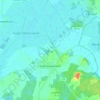
Name: Groß Schulzendorf topographic map, elevation, terrain.
Average elevation: 138 ft
Minimum elevation: 115 ft
Maximum elevation: 266 ft
Make a donation
Gear up for your next adventure:
As an Amazon Associate, this site earns from qualifying purchases at no extra cost to you.