
Thank you for supporting this site ❤️
Make a donation
Make a donation
Gear up for your next adventure:
As an Amazon Associate, this site earns from qualifying purchases at no extra cost to you.
Niederense topographic map
Click on the map to display elevation.
Thank you for supporting this site ❤️
Make a donation
Make a donation
Gear up for your next adventure:
As an Amazon Associate, this site earns from qualifying purchases at no extra cost to you.
About this map
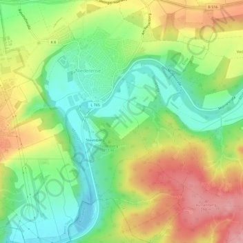
Name: Niederense topographic map, elevation, terrain.
Location: Niederense, Ense, Kreis Soest, Nordrhein-Westfalen, Deutschland (51.46823 7.97623 51.50357 8.02514)
Average elevation: 709 ft
Minimum elevation: 509 ft
Maximum elevation: 965 ft
Thank you for supporting this site ❤️
Make a donation
Make a donation
Gear up for your next adventure:
As an Amazon Associate, this site earns from qualifying purchases at no extra cost to you.