Geolocate

Porter Ranch topographic map

Click on the map to display elevation.

About this map

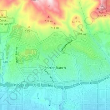
Name: Porter Ranch topographic map, elevation, terrain.

Location: Porter Ranch, Los Angeles, California, United States (34.27233 -118.59165 34.30350 -118.52756)

Average elevation: 1,509 ft

Minimum elevation: 997 ft

Maximum elevation: 2,890 ft

Other topographic maps

Click on a map to view its topography, its elevation and its terrain.

Belvedere Gardens

United States > California > Los Angeles

Average elevation: 249 ft

Gear up for your next adventure:

🏕️Family Camping Gear - Essentials for group camping trips
🛡️Insect Repellent - Protection against bugs during outdoor activities
🧭Hiking Compass - Precision compass for reliable navigation in the wilderness
🌄Hiking Binoculars - Compact binoculars for scenic views and trail spotting
🧭Compass with Lanyard - Easy‑carry compass for navigation

As an Amazon Associate, this site earns from qualifying purchases at no extra cost to you.