
Ksar El Hirane topographic map
Interactive map
Click on the map to display elevation.
About this map
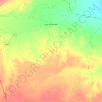
Name: Ksar El Hirane topographic map, elevation, terrain.
Location: Ksar El Hirane, Daïra Ksar El Hirane, Laghouat, 03100, Algérie (33.53714 3.06673 33.86550 3.34619)
Average elevation: 2,533 ft
Minimum elevation: 2,178 ft
Maximum elevation: 3,064 ft
Other topographic maps
Click on a map to view its topography, its elevation and its terrain.
Bennasser Benchohra
Algérie > Laghouat > Daïra Ksar El Hirane > Bennasser Benchohra
Bennasser Benchohra, Daïra Ksar El Hirane, Laghouat, Algérie
Average elevation: 2,661 ft