
Devonshire topographic map
Click on the map to display elevation.
About this map
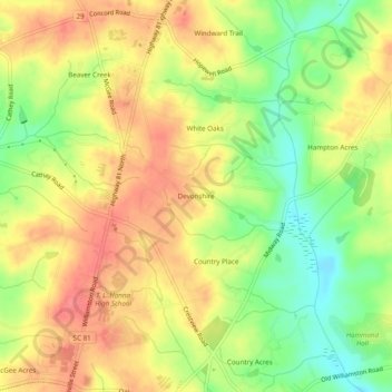
Name: Devonshire topographic map, elevation, terrain.
Location: Devonshire, Anderson County, South Carolina, United States (34.55900 -82.63208 34.59900 -82.59208)
Average elevation: 797 ft
Minimum elevation: 679 ft
Maximum elevation: 886 ft
Anderson County trails, hiking, mountain biking, running and outdoor activities
Other topographic maps
Click on a map to view its topography, its elevation and its terrain.
Homeland Park
United States > South Carolina > Anderson County > Varennes Heights
Average elevation: 768 ft
Centerville
United States > South Carolina > Anderson County > Gilmer Estates
Average elevation: 791 ft