Make a donation
Gear up for your next adventure:
As an Amazon Associate, this site earns from qualifying purchases at no extra cost to you.
SS 24 topographic map
Click on the map to display elevation.
Make a donation
Gear up for your next adventure:
As an Amazon Associate, this site earns from qualifying purchases at no extra cost to you.
About this map
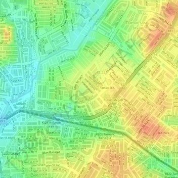
Name: SS 24 topographic map, elevation, terrain.
Location: SS 24, Petaling Jaya, Petaling, Selangor, Malaysia (3.11241 101.60560 3.12121 101.61352)
Average elevation: 144 ft
Minimum elevation: 62 ft
Maximum elevation: 213 ft
Make a donation
Gear up for your next adventure:
As an Amazon Associate, this site earns from qualifying purchases at no extra cost to you.
Other topographic maps
Click on a map to view its topography, its elevation and its terrain.
Taman Subang Indah Kid's Playground & Family Park
Malaysia > Selangor > Petaling Jaya
Average elevation: 82 ft
Make a donation
Gear up for your next adventure:
As an Amazon Associate, this site earns from qualifying purchases at no extra cost to you.
Kota Damansara Community Forest Reserve
Malaysia > Selangor > Petaling Jaya > Prima Damansara
Average elevation: 279 ft
Make a donation
Gear up for your next adventure:
As an Amazon Associate, this site earns from qualifying purchases at no extra cost to you.
