
Make a donation
Gear up for your next adventure:
As an Amazon Associate, this site earns from qualifying purchases at no extra cost to you.
Ponte dos Carvalhos topographic map
Click on the map to display elevation.
Make a donation
Gear up for your next adventure:
As an Amazon Associate, this site earns from qualifying purchases at no extra cost to you.
About this map
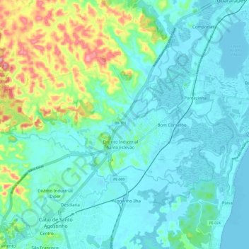
Name: Ponte dos Carvalhos topographic map, elevation, terrain.
Average elevation: 112 ft
Minimum elevation: -3 ft
Maximum elevation: 518 ft
Make a donation
Gear up for your next adventure:
As an Amazon Associate, this site earns from qualifying purchases at no extra cost to you.
Other topographic maps
Click on a map to view its topography, its elevation and its terrain.
Região Metropolitana do Recife
Brasil > Pernambuco > Região Metropolitana do Recife > Cabo de Santo Agostinho
Average elevation: 390 ft
Rio Gurjaú
Brasil > Pernambuco > Região Metropolitana do Recife > Cabo de Santo Agostinho
Average elevation: 59 ft
Praça 09 de Julho
Brasil > Pernambuco > Região Metropolitana do Recife > Cabo de Santo Agostinho
Average elevation: 59 ft