
Make a donation
Gear up for your next adventure:
As an Amazon Associate, this site earns from qualifying purchases at no extra cost to you.
Ingonish topographic map
Click on the map to display elevation.
Make a donation
Gear up for your next adventure:
As an Amazon Associate, this site earns from qualifying purchases at no extra cost to you.
About this map
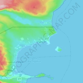
Name: Ingonish topographic map, elevation, terrain.
Average elevation: 128 ft
Minimum elevation: -3 ft
Maximum elevation: 948 ft
Make a donation
Gear up for your next adventure:
As an Amazon Associate, this site earns from qualifying purchases at no extra cost to you.
Other topographic maps
Click on a map to view its topography, its elevation and its terrain.
Sandy Beach
Canada > Nova Scotia > Municipality of Victoria County > Cape Dauphin
Average elevation: 177 ft
Shoal Point
Canada > Nova Scotia > Municipality of Victoria County > New Haven
Average elevation: 62 ft
Pattersons Lake
Canada > Nova Scotia > Municipality of Victoria County > Boularderie East
Average elevation: 276 ft