
Make a donation
Gear up for your next adventure:
As an Amazon Associate, this site earns from qualifying purchases at no extra cost to you.
Krasnoyarsk topographic map
Click on the map to display elevation.
Make a donation
Gear up for your next adventure:
As an Amazon Associate, this site earns from qualifying purchases at no extra cost to you.
Krasnoyarsk
The river Yenisei flows from west to east through the city. Due to the Krasnoyarsk hydroelectric dam 32 km (20 mi) upstream, the Yenisei never freezes in winter and never exceeds +14 °C (57 °F) in summer through the city. Near the city center, its elevation is 136 m (446 ft) above sea level. There are several islands in the river, the largest of which are Tatyshev and Otdyha Isles, used mainly for recreation.
Make a donation
Gear up for your next adventure:
As an Amazon Associate, this site earns from qualifying purchases at no extra cost to you.
About this map
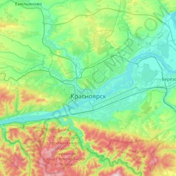
Name: Krasnoyarsk topographic map, elevation, terrain.
Average elevation: 935 ft
Minimum elevation: 387 ft
Maximum elevation: 2,598 ft
Make a donation
Gear up for your next adventure:
As an Amazon Associate, this site earns from qualifying purchases at no extra cost to you.