Geolocate

Baracatan topographic map

Click on the map to display elevation.

About this map

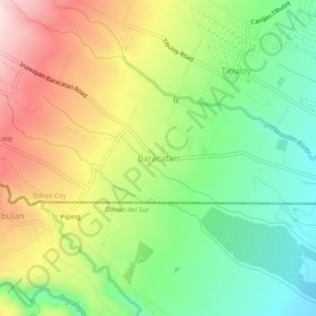
Name: Baracatan topographic map, elevation, terrain.

Location: Baracatan, Davao City, Davao Region, Philippines (6.95181 125.40761 6.99181 125.44761)

Average elevation: 1,171 ft

Minimum elevation: 571 ft

Maximum elevation: 1,975 ft

Other topographic maps

Click on a map to view its topography, its elevation and its terrain.

Tamayong

Philippines > Davao City

Average elevation: 2,552 ft

75-A Matina Aplaya

Philippines > Davao City

Average elevation: 10 ft

Matina River

Philippines > Davao City > Matina Pangi

Average elevation: 203 ft

Baguio District

Philippines > Davao City

Average elevation: 1,847 ft

Matina Pangi

Philippines > Davao City

Average elevation: 174 ft

26-C Silangan

Philippines > Davao City

Average elevation: 13 ft

Lipadas River

Philippines > Davao City

Average elevation: 4,432 ft

Mapula River

Philippines > Davao City

Average elevation: 1,467 ft

Wilfredo Aquino

Philippines > Davao City

Average elevation: 33 ft

Ma-a

Philippines > Davao City

Average elevation: 118 ft

Ogdoy River

Philippines > Davao City

Average elevation: 433 ft

Maa Creek

Philippines > Davao City

Average elevation: 131 ft

Gear up for your next adventure:

🥾Men's Hiking Boots - Durable, waterproof footwear for rugged terrain and steep inclines
📦Gear Storage Bags - Organize and protect outdoor equipment
GPS Sports Watch - GPS watch for running, hiking and training
⛑️Personal Locator Beacon - Safety beacon for emergencies
🌎3D Topographic Globes - Raised relief globes for a tactile understanding of geography

As an Amazon Associate, this site earns from qualifying purchases at no extra cost to you.