
Make a donation
Gear up for your next adventure:
As an Amazon Associate, this site earns from qualifying purchases at no extra cost to you.
Sungai Long topographic map
Click on the map to display elevation.
Make a donation
Gear up for your next adventure:
As an Amazon Associate, this site earns from qualifying purchases at no extra cost to you.
About this map
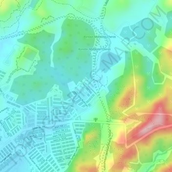
Name: Sungai Long topographic map, elevation, terrain.
Average elevation: 358 ft
Minimum elevation: 164 ft
Maximum elevation: 837 ft
Make a donation
Gear up for your next adventure:
As an Amazon Associate, this site earns from qualifying purchases at no extra cost to you.
Other topographic maps
Click on a map to view its topography, its elevation and its terrain.
Make a donation
Gear up for your next adventure:
As an Amazon Associate, this site earns from qualifying purchases at no extra cost to you.
Make a donation
Gear up for your next adventure:
As an Amazon Associate, this site earns from qualifying purchases at no extra cost to you.
Kampung Batu Lima
Malaysia > Selangor > Kajang Municipal Council > Bangi Lama
Average elevation: 128 ft
Bandar Baru Bangi
Malaysia > Selangor > Kajang Municipal Council > Bandar Baru Bangi
Average elevation: 154 ft
Make a donation
Gear up for your next adventure:
As an Amazon Associate, this site earns from qualifying purchases at no extra cost to you.
Make a donation
Gear up for your next adventure:
As an Amazon Associate, this site earns from qualifying purchases at no extra cost to you.
Kampung Sungai Semungkis
Malaysia > Selangor > Kajang Municipal Council > Batu 14 Hulu Langat
Average elevation: 279 ft
Make a donation
Gear up for your next adventure:
As an Amazon Associate, this site earns from qualifying purchases at no extra cost to you.
Kampung Orang Asli Paya Lebar
Malaysia > Selangor > Kajang Municipal Council
Average elevation: 817 ft
Make a donation
Gear up for your next adventure:
As an Amazon Associate, this site earns from qualifying purchases at no extra cost to you.
Kampung Orang Asli Kuala Pangsun
Malaysia > Selangor > Kajang Municipal Council
Average elevation: 771 ft
Make a donation
Gear up for your next adventure:
As an Amazon Associate, this site earns from qualifying purchases at no extra cost to you.
Make a donation
Gear up for your next adventure:
As an Amazon Associate, this site earns from qualifying purchases at no extra cost to you.
Make a donation
Gear up for your next adventure:
As an Amazon Associate, this site earns from qualifying purchases at no extra cost to you.
Kampung Sungai Semungkis
Malaysia > Selangor > Kajang Municipal Council > Kampung Batu 16
Average elevation: 279 ft
Make a donation
Gear up for your next adventure:
As an Amazon Associate, this site earns from qualifying purchases at no extra cost to you.