
Thank you for supporting this site ❤️
Make a donation
Make a donation
Gear up for your next adventure:
As an Amazon Associate, this site earns from qualifying purchases at no extra cost to you.
Moerbrugge topographic map
Click on the map to display elevation.
Thank you for supporting this site ❤️
Make a donation
Make a donation
Gear up for your next adventure:
As an Amazon Associate, this site earns from qualifying purchases at no extra cost to you.
About this map
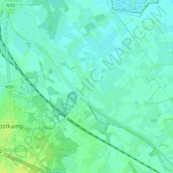
Name: Moerbrugge topographic map, elevation, terrain.
Location: Moerbrugge, Oostkamp, Brugge, West-Vlaanderen, 8020, België (51.14232 3.24312 51.18232 3.28312)
Average elevation: 20 ft
Minimum elevation: 3 ft
Maximum elevation: 49 ft
Thank you for supporting this site ❤️
Make a donation
Make a donation
Gear up for your next adventure:
As an Amazon Associate, this site earns from qualifying purchases at no extra cost to you.