
Make a donation
Gear up for your next adventure:
As an Amazon Associate, this site earns from qualifying purchases at no extra cost to you.
Araguari topographic map
Click on the map to display elevation.
Make a donation
Gear up for your next adventure:
As an Amazon Associate, this site earns from qualifying purchases at no extra cost to you.
Araguari
Araguari is a municipality in western Minas Gerais state, Brazil. It is in the northern Triângulo Mineiro region, on the Jordão River, a tributary of the Paranaíba River, at an elevation between 940 and 1,087 metres (3,084 and 3,566 ft). The municipality of Araguari has an area of 2,774 km2 (1,071 sq mi), with 54 km2 (21 sq mi) in the urban zone and 2,675 km2 (1,033 sq mi) in the rural zone. The population in 2020 was 117,825, making it the third-most important city in the Triângulo Mineiro, after Uberlândia and Uberaba. Araguari has also been one of the fastest-growing cities in Brazil, growing more than the rest of the country in proportion.
Make a donation
Gear up for your next adventure:
As an Amazon Associate, this site earns from qualifying purchases at no extra cost to you.
About this map
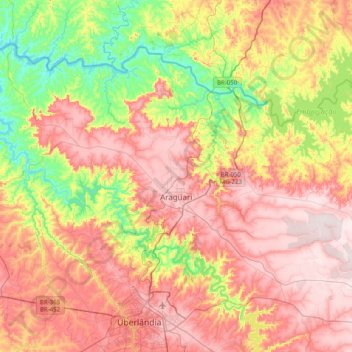
Name: Araguari topographic map, elevation, terrain.
Average elevation: 2,477 ft
Minimum elevation: 1,647 ft
Maximum elevation: 3,343 ft
Make a donation
Gear up for your next adventure:
As an Amazon Associate, this site earns from qualifying purchases at no extra cost to you.
Other topographic maps
Click on a map to view its topography, its elevation and its terrain.
Belo Horizonte
Brazil > Minas Gerais > Região Metropolitana de Belo Horizonte > Belo Horizonte
In 1893, due to the climatic and topographic conditions, Curral Del Rey was selected by Minas Gerais governor Afonso Pena among other cities as the location for the new economic and cultural center of the state, under the new name of Cidade de Minas, or City of Minas.
Average elevation: 2,966 ft