Geolocate

Wool topographic map

Click on the map to display elevation.

About this map

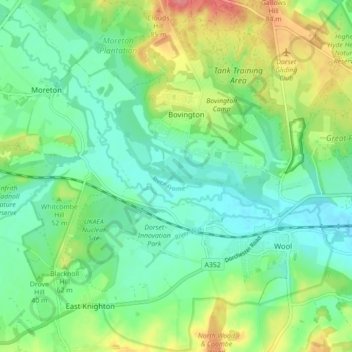
Name: Wool topographic map, elevation, terrain.

Location: Wool, Bovington, Dorset, England, United Kingdom (50.66210 -2.27022 50.71784 -2.19449)

Average elevation: 121 ft

Minimum elevation: 33 ft

Maximum elevation: 302 ft

Gear up for your next adventure:

🗺️NatGeo Topo Maps - High-quality waterproof printed topographic maps of US Parks
🪵Folding Camp Saw - Compact saw for wood and campsite work
🥘Titanium Cookware - Durable, featherlight pots and pans for backpacking
🔌USB Car Charger - Car charger for on‑the‑go power needs
🧭Orienteering Set - Complete compass and map reading kit

As an Amazon Associate, this site earns from qualifying purchases at no extra cost to you.