
Make a donation
Gear up for your next adventure:
As an Amazon Associate, this site earns from qualifying purchases at no extra cost to you.
Monnaie topographic map
Click on the map to display elevation.
Make a donation
Gear up for your next adventure:
As an Amazon Associate, this site earns from qualifying purchases at no extra cost to you.
About this map
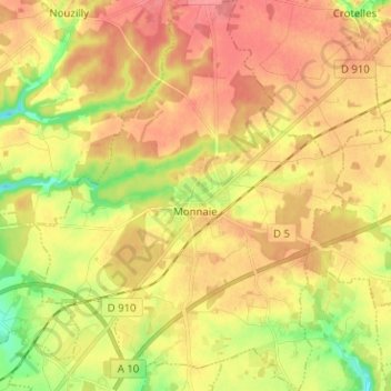
Name: Monnaie topographic map, elevation, terrain.
Average elevation: 400 ft
Minimum elevation: 266 ft
Maximum elevation: 495 ft
Make a donation
Gear up for your next adventure:
As an Amazon Associate, this site earns from qualifying purchases at no extra cost to you.
Other topographic maps
Click on a map to view its topography, its elevation and its terrain.
Jupille
France > Centre-Val de Loire > Indre-et-Loire > Mazières-de-Touraine
Average elevation: 315 ft
Make a donation
Gear up for your next adventure:
As an Amazon Associate, this site earns from qualifying purchases at no extra cost to you.
La Motte Fiche
France > Centre-Val de Loire > Indre-et-Loire > Saint-Germain-sur-Vienne
Average elevation: 184 ft
Make a donation
Gear up for your next adventure:
As an Amazon Associate, this site earns from qualifying purchases at no extra cost to you.
Les Plants de Choux
France > Centre-Val de Loire > Indre-et-Loire > Couziers
Average elevation: 184 ft
Le Boulay
France > Centre-Val de Loire > Indre-et-Loire > Avrillé-les-Ponceaux
Average elevation: 272 ft
Make a donation
Gear up for your next adventure:
As an Amazon Associate, this site earns from qualifying purchases at no extra cost to you.
Les Hermites
France > Centre-Val de Loire > Indre-et-Loire > Nazelles-Négron
Average elevation: 213 ft
Make a donation
Gear up for your next adventure:
As an Amazon Associate, this site earns from qualifying purchases at no extra cost to you.
La Proutière
France > Centre-Val de Loire > Indre-et-Loire > Épeigné-sur-Dême
Average elevation: 348 ft
Make a donation
Gear up for your next adventure:
As an Amazon Associate, this site earns from qualifying purchases at no extra cost to you.
Les Dandillons
France > Centre-Val de Loire > Indre-et-Loire > Azay-le-Rideau
Average elevation: 253 ft
Make a donation
Gear up for your next adventure:
As an Amazon Associate, this site earns from qualifying purchases at no extra cost to you.
Chausseloup
France > Centre-Val de Loire > Indre-et-Loire > Chanceaux-sur-Choisille
Average elevation: 315 ft
La Terre de la Ceuille Roulée
France > Centre-Val de Loire > Indre-et-Loire > Langeais
Average elevation: 292 ft
Les Coutures
France > Centre-Val de Loire > Indre-et-Loire > La Ville-aux-Dames
Average elevation: 187 ft
Make a donation
Gear up for your next adventure:
As an Amazon Associate, this site earns from qualifying purchases at no extra cost to you.
La Foire de Saint-Roch
France > Centre-Val de Loire > Indre-et-Loire > Saint-Roch
Average elevation: 315 ft
Make a donation
Gear up for your next adventure:
As an Amazon Associate, this site earns from qualifying purchases at no extra cost to you.
Saint-Sulpice
France > Centre-Val de Loire > Indre-et-Loire > Chambourg-sur-Indre
Average elevation: 295 ft
Make a donation
Gear up for your next adventure:
As an Amazon Associate, this site earns from qualifying purchases at no extra cost to you.
Le Buisson
France > Centre-Val de Loire > Indre-et-Loire > Tauxigny-Saint-Bauld
Average elevation: 318 ft
Le Stade
France > Centre-Val de Loire > Indre-et-Loire > Montlouis-sur-Loire
Average elevation: 194 ft
Make a donation
Gear up for your next adventure:
As an Amazon Associate, this site earns from qualifying purchases at no extra cost to you.
La Grangette
France > Centre-Val de Loire > Indre-et-Loire > Montlouis-sur-Loire
Average elevation: 194 ft
Make a donation
Gear up for your next adventure:
As an Amazon Associate, this site earns from qualifying purchases at no extra cost to you.
Île de Porteau
France > Centre-Val de Loire > Indre-et-Loire > La Chapelle-sur-Loire
Average elevation: 112 ft
Les Chauvelles
France > Centre-Val de Loire > Indre-et-Loire > Azay-le-Rideau > Lionnière
Average elevation: 266 ft
Parc du Lac des Bretonnières
France > Centre-Val de Loire > Indre-et-Loire > Joué-lès-Tours > La Petite Carte
Average elevation: 279 ft
Make a donation
Gear up for your next adventure:
As an Amazon Associate, this site earns from qualifying purchases at no extra cost to you.
Make a donation
Gear up for your next adventure:
As an Amazon Associate, this site earns from qualifying purchases at no extra cost to you.
La Grange du Bois
France > Centre-Val de Loire > Indre-et-Loire > Épeigné-les-Bois
Average elevation: 344 ft
Make a donation
Gear up for your next adventure:
As an Amazon Associate, this site earns from qualifying purchases at no extra cost to you.
La Tuilerie
France > Centre-Val de Loire > Indre-et-Loire > La Croix-en-Touraine
Average elevation: 243 ft
Château de Villandry
France > Centre-Val de Loire > Indre-et-Loire > Villandry > Le Château
Average elevation: 210 ft
Le Puy Mary
France > Centre-Val de Loire > Indre-et-Loire > Le Petit-Pressigny
Average elevation: 404 ft
Make a donation
Gear up for your next adventure:
As an Amazon Associate, this site earns from qualifying purchases at no extra cost to you.
La Vallée des Caves
France > Centre-Val de Loire > Indre-et-Loire > Rochecorbon
Average elevation: 361 ft
Le Carroi
France > Centre-Val de Loire > Indre-et-Loire > Mazières-de-Touraine
Average elevation: 299 ft
Make a donation
Gear up for your next adventure:
As an Amazon Associate, this site earns from qualifying purchases at no extra cost to you.
Les Bains
France > Centre-Val de Loire > Indre-et-Loire > Saint-Paterne-Racan
Average elevation: 318 ft
Make a donation
Gear up for your next adventure:
As an Amazon Associate, this site earns from qualifying purchases at no extra cost to you.
Parc du Val de Loire
France > Centre-Val de Loire > Indre-et-Loire > Montlouis-sur-Loire > Le Bourg
Average elevation: 207 ft
Make a donation
Gear up for your next adventure:
As an Amazon Associate, this site earns from qualifying purchases at no extra cost to you.
Repos de Saint-Martin
France > Centre-Val de Loire > Indre-et-Loire > Chinon
Average elevation: 154 ft
Les Ansaults
France > Centre-Val de Loire > Indre-et-Loire > Artannes-sur-Indre
Average elevation: 240 ft
Le Sabot Rouge
France > Centre-Val de Loire > Indre-et-Loire > Sainte-Maure-de-Touraine
Average elevation: 322 ft
La Blottière
France > Centre-Val de Loire > Indre-et-Loire > Beaumont-Louestault
Average elevation: 397 ft
Make a donation
Gear up for your next adventure:
As an Amazon Associate, this site earns from qualifying purchases at no extra cost to you.
Les Availlons
France > Centre-Val de Loire > Indre-et-Loire > Yzeures-sur-Creuse
Average elevation: 305 ft
Les Sablons
France > Centre-Val de Loire > Indre-et-Loire > Cléré-les-Pins > Les Sablons
Average elevation: 325 ft
Le Bois de la Grille
France > Centre-Val de Loire > Indre-et-Loire > Chinon > Le Villier
Average elevation: 246 ft
Make a donation
Gear up for your next adventure:
As an Amazon Associate, this site earns from qualifying purchases at no extra cost to you.
Les Hucherolles
France > Centre-Val de Loire > Indre-et-Loire > Chinon > Les Hucherolles
Average elevation: 187 ft
Le Boulay
France > Centre-Val de Loire > Indre-et-Loire > Villedômer > Le Boulay
Average elevation: 387 ft
Les Poulardières
France > Centre-Val de Loire > Indre-et-Loire > Saint-Cyr-sur-Loire
Average elevation: 230 ft
Make a donation
Gear up for your next adventure:
As an Amazon Associate, this site earns from qualifying purchases at no extra cost to you.
Le Télégraphe
France > Centre-Val de Loire > Indre-et-Loire > Chambray-lès-Tours
Average elevation: 282 ft
Le Grand Village
France > Centre-Val de Loire > Indre-et-Loire > La Ville-aux-Dames
Average elevation: 167 ft
Make a donation
Gear up for your next adventure:
As an Amazon Associate, this site earns from qualifying purchases at no extra cost to you.
Make a donation
Gear up for your next adventure:
As an Amazon Associate, this site earns from qualifying purchases at no extra cost to you.
Périgourd
France > Centre-Val de Loire > Indre-et-Loire > Saint-Cyr-sur-Loire
Average elevation: 279 ft
Les Muriers
France > Centre-Val de Loire > Indre-et-Loire > Saint-Pierre-des-Corps
Average elevation: 190 ft
Longboyau
France > Centre-Val de Loire > Indre-et-Loire > Savigné-sur-Lathan
Average elevation: 295 ft
Make a donation
Gear up for your next adventure:
As an Amazon Associate, this site earns from qualifying purchases at no extra cost to you.
La Grosse Chaintre
France > Centre-Val de Loire > Indre-et-Loire > La Ville-aux-Dames
Average elevation: 200 ft
La Derouette
France > Centre-Val de Loire > Indre-et-Loire > Coteaux-sur-Loire
Average elevation: 154 ft
La Blonderie
France > Centre-Val de Loire > Indre-et-Loire > Beaumont-Louestault
Average elevation: 430 ft
Make a donation
Gear up for your next adventure:
As an Amazon Associate, this site earns from qualifying purchases at no extra cost to you.