
Pasterze topographic map
Click on the map to display elevation.
About this map
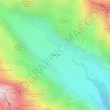
Name: Pasterze topographic map, elevation, terrain.
Average elevation: 8,527 ft
Minimum elevation: 6,847 ft
Maximum elevation: 11,824 ft
Other topographic maps
Click on a map to view its topography, its elevation and its terrain.
High Tauern National Park
Austria > Carinthia > Bezirk Spittal an der Drau > Heiligenblut am Großglockner
Average elevation: 5,610 ft
Heiligenblut
Austria > Carinthia > Bezirk Spittal an der Drau > Heiligenblut am Großglockner
Average elevation: 6,503 ft