
Make a donation
Gear up for your next adventure:
As an Amazon Associate, this site earns from qualifying purchases at no extra cost to you.
Rock Hill topographic map
Click on the map to display elevation.
Make a donation
Gear up for your next adventure:
As an Amazon Associate, this site earns from qualifying purchases at no extra cost to you.
Rock Hill
Rock Hill is located along the Catawba River in the north-central section of the Piedmont of South Carolina, south of the city of Charlotte in North Carolina. The city sits at an elevation of around 676 feet (206 m) above sea level. It is located approximately 150 miles (240 km) from the Atlantic Ocean and 75 miles (121 km) from the Blue Ridge Mountains. The northern limits of the city reside along Lake Wylie, a large man-made reservoir.
Make a donation
Gear up for your next adventure:
As an Amazon Associate, this site earns from qualifying purchases at no extra cost to you.
About this map
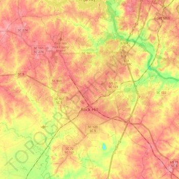
Name: Rock Hill topographic map, elevation, terrain.
Location: Rock Hill, York County, South Carolina, United States (34.87084 -81.12522 35.01481 -80.92810)
Average elevation: 604 ft
Minimum elevation: 381 ft
Maximum elevation: 741 ft
York County trails, hiking, mountain biking, running and outdoor activities
Make a donation
Gear up for your next adventure:
As an Amazon Associate, this site earns from qualifying purchases at no extra cost to you.
Other topographic maps
Click on a map to view its topography, its elevation and its terrain.
Make a donation
Gear up for your next adventure:
As an Amazon Associate, this site earns from qualifying purchases at no extra cost to you.
Boyd Hill
United States > South Carolina > York County > Rock Hill > Boyd Hill
Average elevation: 630 ft
Rock Hill
United States > South Carolina > York County > Rock Hill > Rock Hill
Average elevation: 607 ft