Geolocate

Indian Point topographic map

Click on the map to display elevation.

About this map

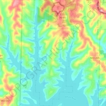
Name: Indian Point topographic map, elevation, terrain.

Location: Indian Point, Stone County, Missouri, United States (36.61588 -93.35620 36.67430 -93.32881)

Average elevation: 1,043 ft

Minimum elevation: 889 ft

Maximum elevation: 1,375 ft

Stone County trails, hiking, mountain biking, running and outdoor activities

Other topographic maps

Click on a map to view its topography, its elevation and its terrain.

Lakeview

United States > Missouri > Stone County > Branson West

Average elevation: 1,253 ft

Radical

United States > Missouri > Stone County > Kimberling City

Average elevation: 965 ft

Lampe

United States > Missouri > Stone County

Average elevation: 1,119 ft

Gear up for your next adventure:

❄️Traction Cleats - Prevent slips on icy trails during winter hikes
🌡️Portable Weather Meter - Track weather conditions on the trail
🔋Rechargeable Batteries - Power up your outdoor devices
🪶Compact Camp Shovel - Folding shovel for campsite tasks
🧢Sun Protection Hats - Wide-brimmed and UPF-rated hats for high-altitude sun safety

As an Amazon Associate, this site earns from qualifying purchases at no extra cost to you.