
Make a donation
Gear up for your next adventure:
As an Amazon Associate, this site earns from qualifying purchases at no extra cost to you.
Erda topographic map
Click on the map to display elevation.
Make a donation
Gear up for your next adventure:
As an Amazon Associate, this site earns from qualifying purchases at no extra cost to you.
About this map
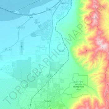
Name: Erda topographic map, elevation, terrain.
Location: Erda, Tooele County, Utah, 84074, United States (40.56499 -112.39486 40.63899 -112.17529)
Average elevation: 5,259 ft
Minimum elevation: 4,193 ft
Maximum elevation: 9,311 ft
Tooele County trails, hiking, mountain biking, running and outdoor activities
Make a donation
Gear up for your next adventure:
As an Amazon Associate, this site earns from qualifying purchases at no extra cost to you.
Other topographic maps
Click on a map to view its topography, its elevation and its terrain.
Ibapah
United States > Utah > Tooele County
The climate is typical of that of a high elevation Great Basin location, being semi-arid and featuring, in consequence, large differences in temperature between day and night.
Average elevation: 5,325 ft