
Make a donation
Gear up for your next adventure:
As an Amazon Associate, this site earns from qualifying purchases at no extra cost to you.
Fredonia Township topographic map
Click on the map to display elevation.
Make a donation
Gear up for your next adventure:
As an Amazon Associate, this site earns from qualifying purchases at no extra cost to you.
About this map
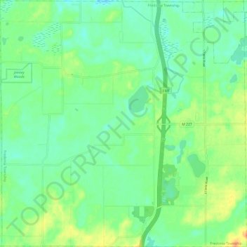
Name: Fredonia Township topographic map, elevation, terrain.
Location: Fredonia Township, Calhoun County, Michigan, United States (42.15948 -85.06111 42.24702 -84.94276)
Average elevation: 945 ft
Minimum elevation: 892 ft
Maximum elevation: 1,050 ft
Calhoun County trails, hiking, mountain biking, running and outdoor activities
Make a donation
Gear up for your next adventure:
As an Amazon Associate, this site earns from qualifying purchases at no extra cost to you.
Other topographic maps
Click on a map to view its topography, its elevation and its terrain.
Make a donation
Gear up for your next adventure:
As an Amazon Associate, this site earns from qualifying purchases at no extra cost to you.
Make a donation
Gear up for your next adventure:
As an Amazon Associate, this site earns from qualifying purchases at no extra cost to you.
Battle Creek
United States > Michigan > Calhoun County > Battle Creek > Battle Creek
Average elevation: 915 ft