
Thank you for supporting this site ❤️
Make a donation
Make a donation
Gear up for your next adventure:
As an Amazon Associate, this site earns from qualifying purchases at no extra cost to you.
Paskuqan topographic map
Click on the map to display elevation.
Thank you for supporting this site ❤️
Make a donation
Make a donation
Gear up for your next adventure:
As an Amazon Associate, this site earns from qualifying purchases at no extra cost to you.
About this map
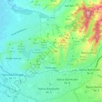
Name: Paskuqan topographic map, elevation, terrain.
Location: Paskuqan, Kamez, Tirana County, Central Albania, 1047, Albania (41.34792 19.77657 41.37836 19.85505)
Average elevation: 390 ft
Minimum elevation: 200 ft
Maximum elevation: 994 ft
Thank you for supporting this site ❤️
Make a donation
Make a donation
Gear up for your next adventure:
As an Amazon Associate, this site earns from qualifying purchases at no extra cost to you.