Geolocate

Monkayo topographic map

Click on the map to display elevation.

About this map

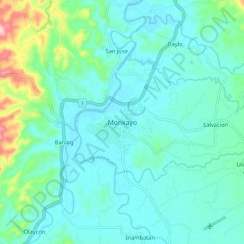
Name: Monkayo topographic map, elevation, terrain.

Location: Monkayo, Davao de Oro, Davao Region, 8805, Philippines (7.78395 126.01369 7.86395 126.09369)

Average elevation: 282 ft

Minimum elevation: 154 ft

Maximum elevation: 863 ft

Other topographic maps

Click on a map to view its topography, its elevation and its terrain.

Laak

Philippines > Davao de Oro

Average elevation: 554 ft

New Bataan

Philippines > Davao de Oro

Average elevation: 2,457 ft

Gear up for your next adventure:

🕶️Glacier Sunglasses - Side shields to protect eyes from high-altitude snow glare
🪑Ultralight Camp Chairs - Portable seating for resting after a long day of mapping
🔊Portable Camp Speaker - Music and alerts at camp
📖Nature Tracking Books - Learn to track wildlife and terrain
📱Heavy-Duty Phone Cases - Drop-proof and waterproof protection for outdoor navigation

As an Amazon Associate, this site earns from qualifying purchases at no extra cost to you.