
Make a donation
Gear up for your next adventure:
As an Amazon Associate, this site earns from qualifying purchases at no extra cost to you.
Reinhartsmais topographic map
Click on the map to display elevation.
Make a donation
Gear up for your next adventure:
As an Amazon Associate, this site earns from qualifying purchases at no extra cost to you.
Reinhartsmais
Aden | Augrub | Bärndorf | Bettmannsäge | Dreieck | Ebenhof | Ecklend | Edhof | Eggenried | Finkenried | Frauenmühle | Großseiboldsried | Huberhof | Kagerhof | Kattersdorf | Kerschlhöh | Kleinseiboldsried | Kreuzerhof | Kühhof | March | Maschenberg | Matzelsried | Metten | Neigerhöhe | Neigermühle | Neusohl | Obermitterdorf | Oberneumais | Oleumhütte | Pfistermühle | Pometsau | Poschetsried | Regen | Reinhartsmais | Richtplatz | Riedham | Rinchnachmündt | Rohrbach | Sallitz | Schauerhof | Schlossau | Schochert | Schollenried | Schönhöh | Schützenhof | Schwaighof | Schweinhütt | Spitalhof | Sumpering | Tausendbach | Thanhof | Thurnhof | Weißenstein | Weißensteiner-Au | Wickersdorf | Wieshof | Windschnur
Make a donation
Gear up for your next adventure:
As an Amazon Associate, this site earns from qualifying purchases at no extra cost to you.
About this map
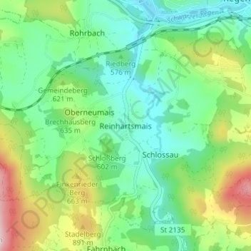
Name: Reinhartsmais topographic map, elevation, terrain.
Average elevation: 1,982 ft
Minimum elevation: 1,693 ft
Maximum elevation: 2,612 ft
Make a donation
Gear up for your next adventure:
As an Amazon Associate, this site earns from qualifying purchases at no extra cost to you.