
Thank you for supporting this site ❤️
Make a donation
Make a donation
Gear up for your next adventure:
As an Amazon Associate, this site earns from qualifying purchases at no extra cost to you.
Picaihua topographic map
Click on the map to display elevation.
Thank you for supporting this site ❤️
Make a donation
Make a donation
Gear up for your next adventure:
As an Amazon Associate, this site earns from qualifying purchases at no extra cost to you.
About this map
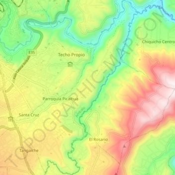
Name: Picaihua topographic map, elevation, terrain.
Location: Picaihua, Ambato, Tungurahua, Ecuador (-1.31155 -78.60795 -1.22985 -78.54918)
Average elevation: 8,566 ft
Minimum elevation: 7,300 ft
Maximum elevation: 10,112 ft
Thank you for supporting this site ❤️
Make a donation
Make a donation
Gear up for your next adventure:
As an Amazon Associate, this site earns from qualifying purchases at no extra cost to you.