
江谷水库 topographic map
Interactive map
Click on the map to display elevation.
About this map
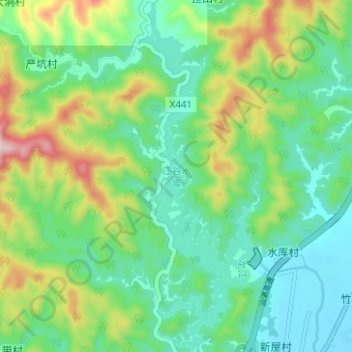
Name: 江谷水库 topographic map, elevation, terrain.
Location: 江谷水库, 四会市, 肇庆市, 广东省, 中国 (23.51028 112.62561 23.56749 112.64692)
Average elevation: 377 ft
Minimum elevation: 59 ft
Maximum elevation: 1,112 ft
江谷水库是中国广东省肇庆市四会市境内的一座水库,位于北江上,建于1969年。水库正常库容为3270万立方米,平均水深为11.69米,集雨面积为137平方千米,海拔为53.5米。
Other topographic maps
Click on a map to view its topography, its elevation and its terrain.