
Make a donation
Gear up for your next adventure:
As an Amazon Associate, this site earns from qualifying purchases at no extra cost to you.
Freedom topographic map
Click on the map to display elevation.
Make a donation
Gear up for your next adventure:
As an Amazon Associate, this site earns from qualifying purchases at no extra cost to you.
About this map
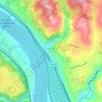
Name: Freedom topographic map, elevation, terrain.
Location: Freedom, Beaver County, Pennsylvania, United States (40.67396 -80.26608 40.69589 -80.24267)
Average elevation: 863 ft
Minimum elevation: 669 ft
Maximum elevation: 1,168 ft
Beaver County trails, hiking, mountain biking, running and outdoor activities
Make a donation
Gear up for your next adventure:
As an Amazon Associate, this site earns from qualifying purchases at no extra cost to you.
Other topographic maps
Click on a map to view its topography, its elevation and its terrain.
North Rochester
United States > Pennsylvania > Beaver County > Rochester Township
Average elevation: 928 ft
Cannelton
United States > Pennsylvania > Beaver County > Darlington Township
Average elevation: 1,014 ft
Ambridge Heights
United States > Pennsylvania > Beaver County > Harmony Township
Average elevation: 912 ft
Make a donation
Gear up for your next adventure:
As an Amazon Associate, this site earns from qualifying purchases at no extra cost to you.
Rowtown
United States > Pennsylvania > Beaver County > South Beaver Township > Rowtown
Average elevation: 1,056 ft