Geolocate

Infanta topographic map

Click on the map to display elevation.

About this map

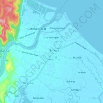
Name: Infanta topographic map, elevation, terrain.

Location: Infanta, Quezon, Calabarzon, 4336, Philippines (14.70588 121.60728 14.78588 121.68728)

Average elevation: 52 ft

Minimum elevation: -10 ft

Maximum elevation: 617 ft

Other topographic maps

Click on a map to view its topography, its elevation and its terrain.

Agos River

Philippines > Quezon > Infanta > Pinaglapatan

Average elevation: 3 ft

Agos River

Philippines > Quezon > Infanta > Pinaglapatan

Average elevation: 3 ft

Gear up for your next adventure:

📚Navigation Handbooks - Master the art of reading topographic maps and using a compass
🧦Hiking Socks - Comfortable socks to prevent blisters on long hikes
⛑️Personal Locator Beacon - Safety beacon for emergencies
🧴Hand Sanitizer - Keep hands clean while hiking
🛶Inflatable Kayak - Portable kayak for rivers, lakes, and expeditions

As an Amazon Associate, this site earns from qualifying purchases at no extra cost to you.