Geolocate

Volendam topographic map

Click on the map to display elevation.

About this map

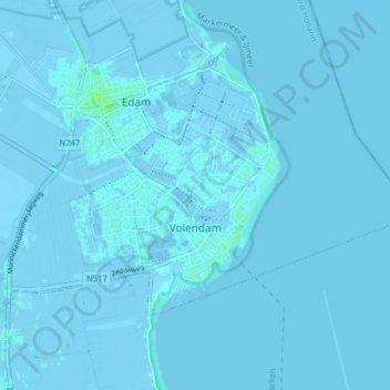
Name: Volendam topographic map, elevation, terrain.

Location: Volendam, Edam-Volendam, North Holland, Netherlands (52.48552 5.03391 52.51518 5.11299)

Average elevation: 0 ft

Minimum elevation: -20 ft

Maximum elevation: 16 ft

Other topographic maps

Click on a map to view its topography, its elevation and its terrain.

Oosterwijzend

Netherlands > North Holland > Hoogkarspel

Average elevation: -7 ft

Overveen

Netherlands > North Holland > Overveen > Overveen

Average elevation: 23 ft

Haarlem

Netherlands > North Holland > Haarlem

Average elevation: 0 ft

Hoofddorp

Netherlands > North Holland > Hoofddorp > Hoofddorp

Average elevation: -10 ft

Wormer

Netherlands > North Holland > Wormer > Wormer

Average elevation: -3 ft

Valkeveen

Netherlands > North Holland > Naarden

Average elevation: 7 ft

Gear up for your next adventure:

👟Men's Trail Runners - Lightweight footwear for fast-paced exploration and light hiking
🛠️Backpacking Tool Kit - Essential toolkit for outdoor repairs
🗻Climbing Gear Basics - Essential gear for beginner climbers
🩳Quick‑Dry Hiking Shorts - Comfortable and quick‑dry shorts for summer hiking
🧭Outdoor Navigation Book - Learn advanced navigation skills

As an Amazon Associate, this site earns from qualifying purchases at no extra cost to you.