
Make a donation
Gear up for your next adventure:
As an Amazon Associate, this site earns from qualifying purchases at no extra cost to you.
Wontergem topographic map
Click on the map to display elevation.
Make a donation
Gear up for your next adventure:
As an Amazon Associate, this site earns from qualifying purchases at no extra cost to you.
Wontergem
Het licht glooiende landschap rond het dorp, behorend tot Zandlemig Vlaanderen, is enigszins gaaf gebleven. De hoogte bedraagt ongeveer 12 meter. In het zuiden ligt de Oude Mandel. Verder is er de Vondelbeek met het natuurgebied Vondelmeersen.
Make a donation
Gear up for your next adventure:
As an Amazon Associate, this site earns from qualifying purchases at no extra cost to you.
About this map
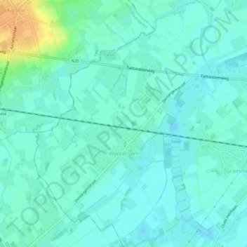
Name: Wontergem topographic map, elevation, terrain.
Location: Wontergem, Deinze, Gent, Oost-Vlaanderen, België (50.96654 3.42581 50.99854 3.46267)
Average elevation: 39 ft
Minimum elevation: 13 ft
Maximum elevation: 121 ft
Make a donation
Gear up for your next adventure:
As an Amazon Associate, this site earns from qualifying purchases at no extra cost to you.