Geolocate

Mansfield topographic map

Click on the map to display elevation.

About this map

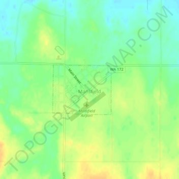
Name: Mansfield topographic map, elevation, terrain.

Location: Mansfield, Douglas County, Washington, 98830, United States (47.80801 -119.64499 47.81564 -119.63183)

Average elevation: 2,264 ft

Minimum elevation: 2,221 ft

Maximum elevation: 2,306 ft

Douglas County trails, hiking, mountain biking, running and outdoor activities

Other topographic maps

Click on a map to view its topography, its elevation and its terrain.

Orondo

United States > Washington > Douglas County

Average elevation: 1,266 ft

Palisades

United States > Washington > Douglas County

Average elevation: 1,581 ft

Beebe

United States > Washington > Douglas County

Average elevation: 1,214 ft

Howard

United States > Washington > Douglas County

Average elevation: 2,707 ft

Nilles Corner

United States > Washington > Douglas County

Average elevation: 2,257 ft

Moses Coulee

United States > Washington > Douglas County

Pleistocene glaciers advanced onto the Waterville Plateau, with the Okanogan Lobe of the Cordilleran Ice Sheet reaching as far south as the town of Withrow. Evidence for glaciation on the Waterville Plateau includes polished and striated bedrock, glacial erratics, drumlinoid topography, eskers, moraines,…

Average elevation: 2,185 ft

Beebe

United States > Washington > Douglas County

Average elevation: 1,214 ft

Gear up for your next adventure:

🧭Compass with Lanyard - Easy‑carry compass for navigation
🗻Climbing Gear Basics - Essential gear for beginner climbers
🏥Hiking First Aid Kits - Comprehensive medical kits for remote trail injuries
🧯Emergency Survival Kit - All‑in‑one survival essentials for the backcountry
🔊Portable Camp Speaker - Music and alerts at camp

As an Amazon Associate, this site earns from qualifying purchases at no extra cost to you.