
Make a donation
Gear up for your next adventure:
As an Amazon Associate, this site earns from qualifying purchases at no extra cost to you.
Feldheim topographic map
Click on the map to display elevation.
Make a donation
Gear up for your next adventure:
As an Amazon Associate, this site earns from qualifying purchases at no extra cost to you.
About this map
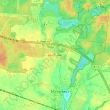
Name: Feldheim topographic map, elevation, terrain.
Average elevation: 174 ft
Minimum elevation: 118 ft
Maximum elevation: 220 ft
Make a donation
Gear up for your next adventure:
As an Amazon Associate, this site earns from qualifying purchases at no extra cost to you.
Other topographic maps
Click on a map to view its topography, its elevation and its terrain.
Schildow
Deutschland > Brandenburg > Oberhavel > Mühlenbecker Land
Die nächstgelegene Eisenbahnstation ist der Haltepunkt Mühlenbeck-Mönchmühle der Berliner S-Bahn im Nachbarortsteil Mühlenbeck. Der zentral gelegene Bahnhof Schildow an der „Heidekrautbahn“ hat keinen regelmäßigen Personenverkehr. In Höhe des Bahnübergangs der Mühlenbecker Straße Schillerstraße…
Average elevation: 144 ft
Lubowsee
Deutschland > Brandenburg > Oberhavel > Mühlenbecker Land > Seefeld
Average elevation: 174 ft
Make a donation
Gear up for your next adventure:
As an Amazon Associate, this site earns from qualifying purchases at no extra cost to you.
Schildow
Deutschland > Brandenburg > Oberhavel > Mühlenbecker Land
Die nächstgelegene Eisenbahnstation ist der Haltepunkt Mühlenbeck-Mönchmühle der Berliner S-Bahn im Nachbarortsteil Mühlenbeck. Der zentral gelegene Bahnhof Schildow an der „Heidekrautbahn“ hat keinen regelmäßigen Personenverkehr. In Höhe des Bahnübergangs der Mühlenbecker Straße Schillerstraße…
Average elevation: 144 ft