
Thank you for supporting this site ❤️
Make a donation
Make a donation
Gear up for your next adventure:
As an Amazon Associate, this site earns from qualifying purchases at no extra cost to you.
Nglanggeran topographic map
Click on the map to display elevation.
Thank you for supporting this site ❤️
Make a donation
Make a donation
Gear up for your next adventure:
As an Amazon Associate, this site earns from qualifying purchases at no extra cost to you.
About this map
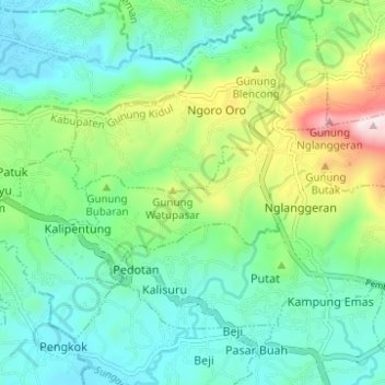
Name: Nglanggeran topographic map, elevation, terrain.
Average elevation: 784 ft
Minimum elevation: 276 ft
Maximum elevation: 2,178 ft
Thank you for supporting this site ❤️
Make a donation
Make a donation
Gear up for your next adventure:
As an Amazon Associate, this site earns from qualifying purchases at no extra cost to you.
Other topographic maps
Click on a map to view its topography, its elevation and its terrain.
Laut Bekah
Indonesia > Special Region of Yogyakarta > Gunung Kidul Regency > Girikarto
Average elevation: 125 ft
Siraman
Indonesia > Special Region of Yogyakarta > Gunung Kidul Regency > Siraman
Average elevation: 581 ft