
Thank you for supporting this site ❤️
Make a donation
Make a donation
Gear up for your next adventure:
As an Amazon Associate, this site earns from qualifying purchases at no extra cost to you.
Pak Nam Tha Ruea topographic map
Click on the map to display elevation.
Thank you for supporting this site ❤️
Make a donation
Make a donation
Gear up for your next adventure:
As an Amazon Associate, this site earns from qualifying purchases at no extra cost to you.
About this map
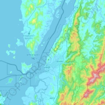
Name: Pak Nam Tha Ruea topographic map, elevation, terrain.
Location: Pak Nam Tha Ruea, Ranong Province, Thailand (9.83106 98.45222 10.15106 98.77222)
Average elevation: 364 ft
Minimum elevation: -7 ft
Maximum elevation: 3,409 ft
Thank you for supporting this site ❤️
Make a donation
Make a donation
Gear up for your next adventure:
As an Amazon Associate, this site earns from qualifying purchases at no extra cost to you.