
Thank you for supporting this site ❤️
Make a donation
Make a donation
Gear up for your next adventure:
As an Amazon Associate, this site earns from qualifying purchases at no extra cost to you.
Nohl topographic map
Click on the map to display elevation.
Thank you for supporting this site ❤️
Make a donation
Make a donation
Gear up for your next adventure:
As an Amazon Associate, this site earns from qualifying purchases at no extra cost to you.
About this map
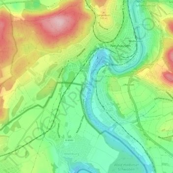
Name: Nohl topographic map, elevation, terrain.
Location: Nohl, Laufen-Uhwiesen, Bezirk Andelfingen, Zurich, 8248, Suisse (47.65173 8.58805 47.69173 8.62805)
Average elevation: 1,440 ft
Minimum elevation: 1,155 ft
Maximum elevation: 1,870 ft
Thank you for supporting this site ❤️
Make a donation
Make a donation
Gear up for your next adventure:
As an Amazon Associate, this site earns from qualifying purchases at no extra cost to you.