
Thank you for supporting this site ❤️
Make a donation
Make a donation
Gear up for your next adventure:
As an Amazon Associate, this site earns from qualifying purchases at no extra cost to you.
Lukovo topographic map
Click on the map to display elevation.
Thank you for supporting this site ❤️
Make a donation
Make a donation
Gear up for your next adventure:
As an Amazon Associate, this site earns from qualifying purchases at no extra cost to you.
About this map
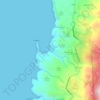
Name: Lukovo topographic map, elevation, terrain.
Location: Lukovo, Senj, Grad Senj, Lika-Senj County, Croatia (44.83531 14.87273 44.87531 14.91273)
Average elevation: 535 ft
Minimum elevation: 0 ft
Maximum elevation: 2,595 ft
Thank you for supporting this site ❤️
Make a donation
Make a donation
Gear up for your next adventure:
As an Amazon Associate, this site earns from qualifying purchases at no extra cost to you.