
Thank you for supporting this site ❤️
Make a donation
Make a donation
Gear up for your next adventure:
As an Amazon Associate, this site earns from qualifying purchases at no extra cost to you.
Weda topographic map
Click on the map to display elevation.
Thank you for supporting this site ❤️
Make a donation
Make a donation
Gear up for your next adventure:
As an Amazon Associate, this site earns from qualifying purchases at no extra cost to you.
About this map
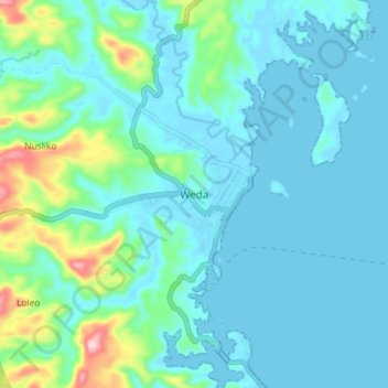
Name: Weda topographic map, elevation, terrain.
Location: Weda, Halmahera Tengah, North Maluku, Maluku, Indonesia (0.29051 127.82896 0.37051 127.90896)
Average elevation: 148 ft
Minimum elevation: -3 ft
Maximum elevation: 906 ft
Thank you for supporting this site ❤️
Make a donation
Make a donation
Gear up for your next adventure:
As an Amazon Associate, this site earns from qualifying purchases at no extra cost to you.