
Make a donation
Gear up for your next adventure:
As an Amazon Associate, this site earns from qualifying purchases at no extra cost to you.
Jawhar topographic map
Click on the map to display elevation.
Make a donation
Gear up for your next adventure:
As an Amazon Associate, this site earns from qualifying purchases at no extra cost to you.
Jawhar
Jawhar is a hill station at 19°55′N 73°14′E / 19.92°N 73.23°E / 19.92; 73.23. Jawhar taluka is tropical and mostly surrounded by deciduous green plants. It has an average elevation of 447 metres (1466 feet). It is about 80 km from Nashik and about 145 km from Mumbai by road.
Make a donation
Gear up for your next adventure:
As an Amazon Associate, this site earns from qualifying purchases at no extra cost to you.
About this map
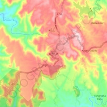
Name: Jawhar topographic map, elevation, terrain.
Location: Jawhar, Jawhar Taluka, Palghar, Maharashtra, 401603, India (19.87248 73.18516 19.95248 73.26516)
Average elevation: 1,237 ft
Minimum elevation: 689 ft
Maximum elevation: 1,686 ft
Make a donation
Gear up for your next adventure:
As an Amazon Associate, this site earns from qualifying purchases at no extra cost to you.