
Make a donation
Gear up for your next adventure:
As an Amazon Associate, this site earns from qualifying purchases at no extra cost to you.
Flag Boshielo topographic map
Click on the map to display elevation.
Make a donation
Gear up for your next adventure:
As an Amazon Associate, this site earns from qualifying purchases at no extra cost to you.
About this map
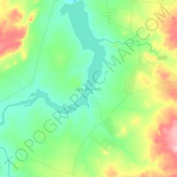
Name: Flag Boshielo topographic map, elevation, terrain.
Average elevation: 2,923 ft
Minimum elevation: 2,602 ft
Maximum elevation: 3,671 ft
Make a donation
Gear up for your next adventure:
As an Amazon Associate, this site earns from qualifying purchases at no extra cost to you.
Other topographic maps
Click on a map to view its topography, its elevation and its terrain.
Marble Hall
South Africa > Limpopo > Sekhukhune District Municipality > Ephraim Mogale Local Municipality
Average elevation: 2,927 ft
Marble Hall
South Africa > Limpopo > Sekhukhune District Municipality > Ephraim Mogale Local Municipality
Average elevation: 2,927 ft