
Le Grand Beaulieu topographic map
Interactive map
Click on the map to display elevation.
About this map
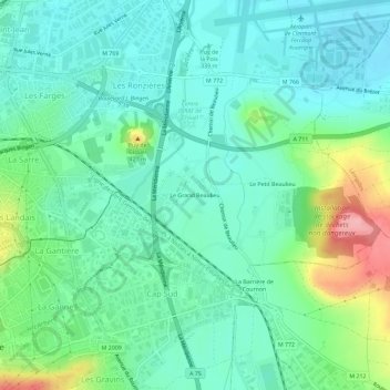
Name: Le Grand Beaulieu topographic map, elevation, terrain.
Average elevation: 1,165 ft
Minimum elevation: 1,053 ft
Maximum elevation: 1,486 ft
Other topographic maps
Click on a map to view its topography, its elevation and its terrain.
Puy de Var
France > Auvergne-Rhône-Alpes > Puy-de-Dôme > Clermont-Ferrand
Puy de Var, Clermont-Ferrand, Puy-de-Dôme, Auvergne-Rhône-Alpes, France métropolitaine, 63112, France
Average elevation: 1,476 ft
Praslong
France > Auvergne-Rhône-Alpes > Puy-de-Dôme > Clermont-Ferrand
Praslong, Clermont-Ferrand, Puy-de-Dôme, Auvergne-Rhône-Alpes, France métropolitaine, 63014, France
Average elevation: 1,099 ft
Puy de Chanturgue
France > Auvergne-Rhône-Alpes > Puy-de-Dôme > Clermont-Ferrand
Puy de Chanturgue, Clermont-Ferrand, Puy-de-Dôme, Auvergne-Rhône-Alpes, France métropolitaine, 63100, France
Average elevation: 1,385 ft